Do Not Talk To Prisoners Through Bars!

burnet-barsa
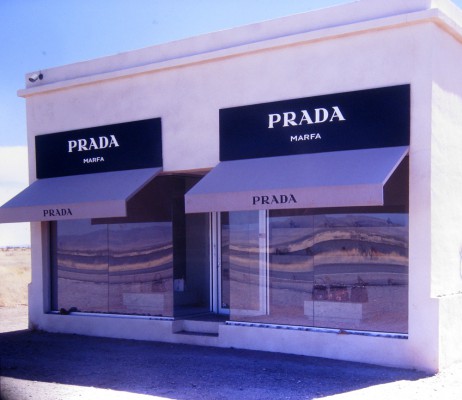
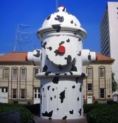
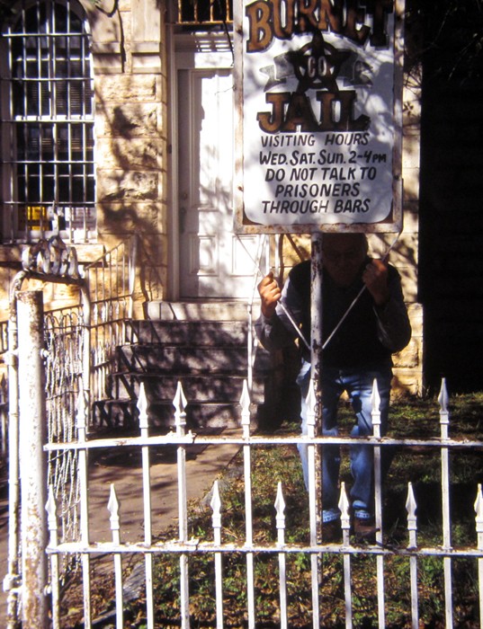
Taken in Burnet, Texas in 2014. This historic jail was built in 1884 of hand-hewn rock. It has an apartment for the sheriff who is also the jailer. On the second floor the county library was founded. The former jail is still being used by one of the county departments. The city of Burnet is nestled in the heart of the Texas Hill Country surrounded by rolling hills, lakes, beautiful geologic formations and historical sites. The historic square features buildings from as early as the 1880’s and offers a variety of unique shops and eateries. Drive in or take the Hill Country Flyer Historic Train (which is what we did) from Cedar Park, located on the edge of Austin. Watch the Burnet Gunfighter’s fight it out at the Old West Town on Saturday and Sunday. Taken with the TL120, available light handheld.


Concepcion Mission Church

Concepcion (1731)

One SA church
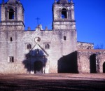
of the most attractive of the San Antonio missions, the church at Concepcion looks essentially as it did more than 200 years ago, when it stood at the center of local religious activity. The mission was well known for its religious celebrations. Not visible today are the colorful geometric designs that originally covered the exterior surface of the mission. Inside, however, are original paintings of religious symbols and architectural designs. These outposts were established by Catholic religious orders to spread Christianity among the local natives. These missions formed part of a colonization system that stretched across the Spanish Southwest in the 17th, 18th, and 19th centuries. This is one of the 5 San Antonio missions, the Alamo is owned by the state of Texas and operated by the Daughters of the Revolution. The National Historical Park encompasses 4 of the missions. Taken with the TL 120.

Prada Marfa

The brainchild of Berlin-based artistic team Elmgreen and Dragset, Prada Marfa was meant to be a “pop architectural land art project.” Built of a biodegradable adobe-like substance, the building is meant to slowly melt back into the Earth, serving as a surrealist commentary on Western materialism. Prada Marfa is located  northwest of Valentine, Texas, just off U.S. Route 90, and about 60 km northwest of the city of Marfa. Costing a sum total of $80,000 – or, put another way, about 40 Prada handbags

pradaDue to vandalism the handbags have no bottoms and all of the shoes are right-footed. While the vandalism might be the most exciting thing that’s ever happened to Prada Marfa, the site still gets thousands of visitors a year, despite Route 90’s low traffic flow Most people buy the artists’ story, but a few vocal dissenters have flooded the internet with conspiracy theories. Some even argue that Prada Marfa is a trap set by aliens meant to attract potential abductees. Visitors beware.


In March of 2014, the Prada in Marfa was vandalized with blue paint and graffiti. Image was taken with the TL 120.


Grrrrrrrrrr!

GrrrrrrrrFormer car parts and spoons take the shapes of mysterious creatures including prehistoric reptiles, bugs, and even aliens at Scrap Daddy’s Art Yard. Art forms are scattered throughout this museum of sorts, among overgrown grass and metal scraps. Welder and gallery owner, Mark Bradford has an eclectic eye for art that has moved him to put his own distinctive mark on the many metal sculptures displayed in the outdoor gallery. Sights for innovative eyes include the 20-foot praying mantis (that I can’t get out of my mind), a flying saucer, and an automobile-sized scorpion. Bradford welcomes free visits to his yard daily.

Where’s the rattlesnakes???

wheres-the-rattlesnakes

I think I goofed and already have the same or similar image in the other folio. Taken at Palo Duro State Park Texas, September 2012. Taken with the TL120 handheld. Palo Duro Canyon State Park opened on July 4, 1934 and contains 29,182 acres of the scenic, northern most portion of the Palo Duro Canyon. The Civilian Conservation Corps of the 1930’s constructed most of the buildings and roads still in use by park staff and visitors.

The Canyon is 120 miles long, as much as 20 miles wide, and has a maximum depth of more than 800 feet. Its elevation at the rim is 3,500 feet above sea level. It is often claimed that Palo Duro Canyon is the second largest canyon in the United States. The largest, the Grand Canyon, is 277 miles long, 18 miles wide, and 6,000 ft. deep.

Palo Duro Canyon was formed by water erosion from the Prairie Dog Town Fork of the Red River. The water deepens the canyon by moving sediment downstream. Wind and water erosion gradually widen the canyon.

Early Spanish Explorers are believed to have discovered the area and dubbed the canyon “Palo Duro” which is Spanish for “hard wood” in reference to the abundant mesquite and juniper trees.

God Bless Texas

god-bless-texasThis image was taken with the TL 120 in a cemetery south of San Antonio, Texas. I was looking for a different kind of cemetery image. It sort of worked. Handheld under a bright sunny Texas sky. This was taken in 2012 when we had a bumper crop of color. I didn’t think to take thumbnails of my photos before I sent the folio on. So I dug out the extras I had and used the closest match.


El Coronado Visitor Center Palo Duro Canyon State Park, Texas

Palo Duro Canyon State Park opened on July 4, 1934 and contains 29,182 acres of the scenic, northern most portion of the Palo Duro Canyon. The Civilian Conservation Corps of the 1930’s constructed most of the buildings and roads still in use by park staff and visitors.

The Canyon is 120 miles long, as much as 20 miles wide, and has a maximum depth of more than 800 feet. Its elevation at the rim is 3,500 feet above sea level. It is often claimed that Palo Duro Canyon is the second largest canyon in the United States. The largest, the Grand Canyon, is 277 miles long, 18 miles wide, and 6,000 ft. deep.

Palo Duro is Spanish for “hard wood”. The photo was taken from the roof of our CCC constructed cabin located on the rim of the canyon. Only 3 cabins have a rim “view”. I am fascinated by the CCC work and visit and/or stay in CCC constructed cabins whenever we can.

Bastrop State Park #2

I provided all the relevant data in the previous post on Bastrop State Park. 2011 Texas experienced a severe drought, over 300 million trees died. My photos do not begin to depict the severity of the wildfire in the park. The park will take decades to recover. The Lost Pines of Texas near Bastrop are important as they are the westernmost edge of the species’ natural range.

All photos were shot with the TL120 and I used either Provia or Kodak 100. And they were handheld using natural light. F/stop not recorded nor remembered.

Bastrop State Park, Texas: Crispy Sign

  The fire ignited on the afternoon of September 4, 2011 near Bastrop, Texas with high winds that knocked drought-weary trees into power lines (Bastrop is about 30 miles southeast of Austin). The blaze created a 16-mile-long front line and galloped at 5 miles per hour, speeding through treetops and jumping state roads. It took 250 firefighters from around the country and 160 fire trucks and other equipment three days to contain the fire.  The fire devoured 32,400 acres and destroyed nearly 1,700 homes. The endangered Houston toad was believed to have lost the vast majority of its habitat in the fire. The sign in this photo talks about the Houston toad habitat. The irony is that the sign, in the upper left hand corner, says “Enter with care”.  This is in Bastrop State Park where the fire consumed 96% of the park which was home to the loblolly pines, known as the lost pines. The park is slowly recovering. My photo, taken in November 2012, shows where the underbrush has already made a quick comeback. I added a photo of the fire, not taken by me.