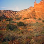
I think I goofed and already have the same or similar image in the other folio. Taken at Palo Duro State Park Texas, September 2012. Taken with the TL120 handheld. Palo Duro Canyon State Park opened on July 4, 1934 and contains 29,182 acres of the scenic, northern most portion of the Palo Duro Canyon. The Civilian Conservation Corps of the 1930’s constructed most of the buildings and roads still in use by park staff and visitors.
The Canyon is 120 miles long, as much as 20 miles wide, and has a maximum depth of more than 800 feet. Its elevation at the rim is 3,500 feet above sea level. It is often claimed that Palo Duro Canyon is the second largest canyon in the United States. The largest, the Grand Canyon, is 277 miles long, 18 miles wide, and 6,000 ft. deep.
Palo Duro Canyon was formed by water erosion from the Prairie Dog Town Fork of the Red River. The water deepens the canyon by moving sediment downstream. Wind and water erosion gradually widen the canyon.
Early Spanish Explorers are believed to have discovered the area and dubbed the canyon “Palo Duro” which is Spanish for “hard wood” in reference to the abundant mesquite and juniper trees.

You must be authenticated to view comments.