Bethel Baptist Church

Bethel church
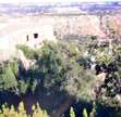
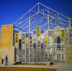
The new Bethel Baptist Church Park was developed while memorializing the history and significance of this land to the Fourth Ward. Fourth Ward was the site of the original Freedmen’s Town neighborhood established by freed slaves after the Civil War. Bethel Missionary Baptist, founded in the late 1800’s by the Rev. Jack Yates, has had three sanctuaries on the same site, the earliest built in the 1890’s. The most recent church building, built in 1923, was gutted by fire in 2005, but the walls are still standing. The city bought the property in 2009 to preserve the church facade and to provide park space. The Bethel Park Project restored three walls and converted the rest of the property into a park. It is a really cool place to sit and meditate.


Where’s the rattlesnakes???

wheres-the-rattlesnakes

I think I goofed and already have the same or similar image in the other folio. Taken at Palo Duro State Park Texas, September 2012. Taken with the TL120 handheld. Palo Duro Canyon State Park opened on July 4, 1934 and contains 29,182 acres of the scenic, northern most portion of the Palo Duro Canyon. The Civilian Conservation Corps of the 1930’s constructed most of the buildings and roads still in use by park staff and visitors.

The Canyon is 120 miles long, as much as 20 miles wide, and has a maximum depth of more than 800 feet. Its elevation at the rim is 3,500 feet above sea level. It is often claimed that Palo Duro Canyon is the second largest canyon in the United States. The largest, the Grand Canyon, is 277 miles long, 18 miles wide, and 6,000 ft. deep.

Palo Duro Canyon was formed by water erosion from the Prairie Dog Town Fork of the Red River. The water deepens the canyon by moving sediment downstream. Wind and water erosion gradually widen the canyon.

Early Spanish Explorers are believed to have discovered the area and dubbed the canyon “Palo Duro” which is Spanish for “hard wood” in reference to the abundant mesquite and juniper trees.

God Bless Texas

god-bless-texasThis image was taken with the TL 120 in a cemetery south of San Antonio, Texas. I was looking for a different kind of cemetery image. It sort of worked. Handheld under a bright sunny Texas sky. This was taken in 2012 when we had a bumper crop of color. I didn’t think to take thumbnails of my photos before I sent the folio on. So I dug out the extras I had and used the closest match.


El Coronado Visitor Center Palo Duro Canyon State Park, Texas

Palo Duro Canyon State Park opened on July 4, 1934 and contains 29,182 acres of the scenic, northern most portion of the Palo Duro Canyon. The Civilian Conservation Corps of the 1930’s constructed most of the buildings and roads still in use by park staff and visitors.

The Canyon is 120 miles long, as much as 20 miles wide, and has a maximum depth of more than 800 feet. Its elevation at the rim is 3,500 feet above sea level. It is often claimed that Palo Duro Canyon is the second largest canyon in the United States. The largest, the Grand Canyon, is 277 miles long, 18 miles wide, and 6,000 ft. deep.

Palo Duro is Spanish for “hard wood”. The photo was taken from the roof of our CCC constructed cabin located on the rim of the canyon. Only 3 cabins have a rim “view”. I am fascinated by the CCC work and visit and/or stay in CCC constructed cabins whenever we can.

Bastrop State Park #2

I provided all the relevant data in the previous post on Bastrop State Park. 2011 Texas experienced a severe drought, over 300 million trees died. My photos do not begin to depict the severity of the wildfire in the park. The park will take decades to recover. The Lost Pines of Texas near Bastrop are important as they are the westernmost edge of the species’ natural range.

All photos were shot with the TL120 and I used either Provia or Kodak 100. And they were handheld using natural light. F/stop not recorded nor remembered.

Bastrop State Park, Texas: Crispy Sign

  The fire ignited on the afternoon of September 4, 2011 near Bastrop, Texas with high winds that knocked drought-weary trees into power lines (Bastrop is about 30 miles southeast of Austin). The blaze created a 16-mile-long front line and galloped at 5 miles per hour, speeding through treetops and jumping state roads. It took 250 firefighters from around the country and 160 fire trucks and other equipment three days to contain the fire.  The fire devoured 32,400 acres and destroyed nearly 1,700 homes. The endangered Houston toad was believed to have lost the vast majority of its habitat in the fire. The sign in this photo talks about the Houston toad habitat. The irony is that the sign, in the upper left hand corner, says “Enter with care”.  This is in Bastrop State Park where the fire consumed 96% of the park which was home to the loblolly pines, known as the lost pines. The park is slowly recovering. My photo, taken in November 2012, shows where the underbrush has already made a quick comeback. I added a photo of the fire, not taken by me.


Sunset at Addicks Dam, Houston, Texas

The place: Addicks Dam ( & reservoir), Houston, about 3 miles from my house.

Time: winter (notice trees)

Camera: Lopp-ified spud on tripod

I will say we can have some pretty cool sunsets here. This is a favorite place for hiking and fishing. Not sure if the fishing is any good. Since it is so close to our house we frequently go here. The Addicks Reservoir and Addicks Dam in conjunction with the Barker Reservoir prevent downstream flooding of Buffalo Bayou in the City of Houston. In addition to the Reservoir’s flood damage reduction mission, recreation and nature observation opportunities abound through the approximately 26,000 acres (105 km²) of land that makes up Addicks and Barker reservoirs.

Buffalo River National Park, Arkansas

The year: 2005

The place: Buffalo River National Park, Arkansas

The weather: very foggy and smoky.

America’s First National River


Established in 1972, Buffalo National River flows freely for 135 miles and is one of the few remaining undammed rivers in the lower 48 states. Once you arrive, prepare to journey from running rapids to quiet pools while surrounded by massive bluffs as you cruise through the Ozark Mountains down to the White River.

It is a spectacular place. However, the area was in drought conditions when we took our trip. People who were canoeing had to portage their craft in many places. No motor craft is allowed on the river. Also, there were wildfires in  New Mexico with the smoke traveling northward. Most of Arkansas was smoke shrouded that summer. We did not do a water trip and saw very few people in canoes. We had a good trip in spite of the weather conditions.

The Buffalo River is connected to the White River, which is connected to the Mississippi, and laps up on the beach of the Gulf states.

The image was shot with the Lopp-ofied spud.

Autumn in Colorado, Ohio Pass

All my images this round were taken with my trusty Don Loppified sputnik. We traveled to Utah & Colorado in September 2011.  I used Kodak film, normally it was the 100vs or 100gx. I hand held the camera and shot f/22 at 50 shutter speed. Light is natural.

This was shot at Ohio Pass, Colorado. It was such a treat for us to see the changing colors in the trees as we only have 2 seasons in Texas: hot and hotter than hell-o 🙂

Cliff Palace #2, Mesa Verde, Colorado

All my images this round were taken with my trusty Don Loppified sputnik.  We traveled to Utah & Colorado in September 2011.  I used Kodak film, normally it was the 100vs or 100gx. I hand held the camera (tripod didn’t make it in either) and shot f/22 at 50 shutter speed. Light is natural.

This was shot at Cliff Palace at Mesa Verde, Colorado.