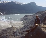
This is the “peninsula” which has figured in many of my recent submissions to the folio.  As you look at this, the Mendenhall Glacier is receding up the valley to your left and the newly exposed rock surfaces are below you on the right. We’ve crossed the peninsula at the highest point you see and walked down to the edge of the ice. We’ve traveled along the edge of the ice and climbed this cliff to have lunch and try to get some perspective.
The blue-ice caves we’ve visited are down at the edge of the ice. The hikers in the center of the frame are heading back to the trail after visiting the glacier. The forest service visitor’s center is visible on the far side of the lake in the center of the frame. In the winter, I’ll skate or ski from there to the glacier to try to capture images of its presence.
Twenty years ago, every inch of this peninsula was under ice. The spot my wife is sitting would have been about 200′ below the surface. Twenty years from now, these smooth cliffs will be covered in scrub alder and willow and the contours will be hidden forever.
Tripod mounted TL120-1
You must be authenticated to view comments.